
Identification of vulnerable areas to flash floods using weighted sum analysis and unsupervised machine learning in arid regions of the northern Atacama Desert
DOI:
https://doi.org/10.17268/sci.agropecu.2025.020Keywords:
Flash floods, Caplina Basin, Weighted Sum Analysis, Unsupervised Machine Learning, Atacama DesertAbstract
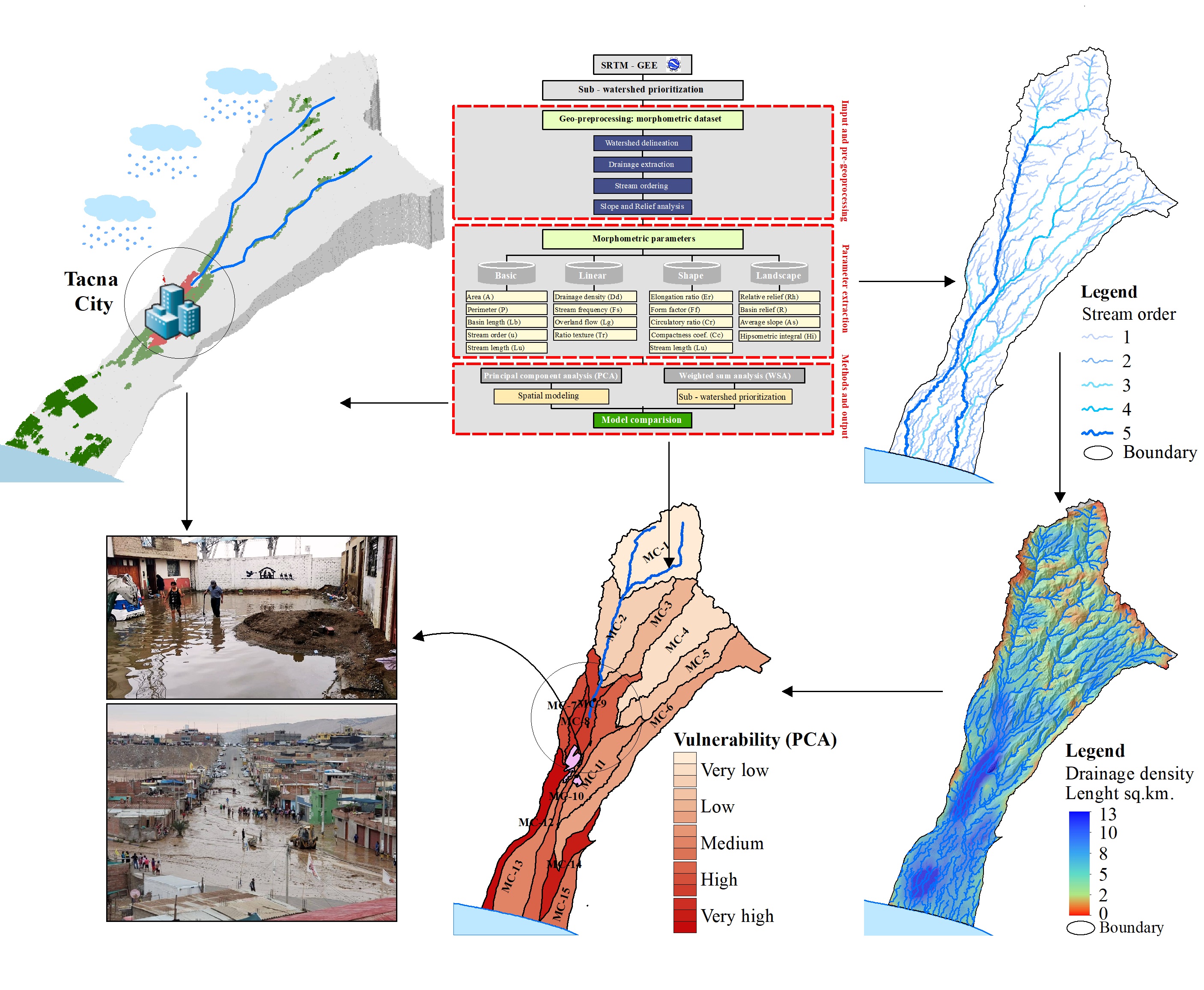
In recent decades, global warming has triggered significant changes in the hydrological cycle, leading to various disasters, especially contrasting events such as droughts and floods. These occurrences have also been recorded in the Atacama Desert, resulting in considerable economic losses worldwide, in Latin America, in Peru, and within the study region. The primary objective of this study is to obtain fundamental morphometric parameters, including basic spatial, linear, shape, and landscape aspects through the integration of GIS tools and artificial intelligence, enabling the identification of flood-prone areas within micro-watersheds. The studied basin is located at the head of the Atacama Desert, in southern Peru, where various lithological and hydro-geomorphological structures influence its vulnerability to floods. To assess flood vulnerability in the Caplina River micro-watersheds, 16 morphometric parameters were precisely analyzed, identifying areas of high vulnerability that require basin management measures. The results show that the hydrological response of the Caplina Basin is strongly influenced by its morphometric characteristics, with micro-watersheds in the middle and lower sections exhibiting higher susceptibility to flash floods. These findings aim to support urban planning and watershed management, offering insights for policymakers to develop flood mitigation strategies and enhance infrastructure resilience.
References
Abdelkareem, M., & Mansour, A. M. (2023). Risk assessment and management of vulnerable areas to flash flood hazards in arid regions using remote sensing and GIS-based knowledge-driven techniques. Nat. Hazards, 117, 2269–2295. https://doi.org/10.1007/s11069-023-05942-x
Adeyeri, O. E., Folorunsho, A. H., Ayegbusi, K. I., Bobde, V., Adeliyi, T. E., Ndehedehe, C. E., & Akinsanola, A. A. (2024). Land surface dynamics and meteorological forcings modulate land surface temperature characteristics. Sustain Cities Soc, 101, 105072. https://doi.org/10.1016/j.scs.2023.105072
Aggarwal, E., Whittaker, A. C., & Gupta, S. (2024). Investigating the influence of river geomorphology on human presence using night light data: A case study in the Indus Basin. Remote Sens (Basel), 16, 1272. https://doi.org/10.3390/rs16071272
Altaf, S., Meraj, G., & Romshoo, S. A. (2014). Morphometry and land cover based multi-criteria analysis for assessing the soil erosion susceptibility of the Western Himalayan Watershed. Environ Monit Assess, 186, 8391–8412. https://doi.org/10.1007/s10661-014-4012-2
Amani, M., Ghorbanian, A., Ahmadi, S. A., Kakooei, M., Moghimi, A., Mirmazloumi, S. M., Moghaddam, S. H. A., Mahdavi, S., Ghahremanloo, M., Parsian, S., Wu, Q., Brisco, B. (2020) Google earth engine cloud computing platform for remote sensing big data applications: A comprehensive review. IEEE J Sel Top Appl Earth Obs Remote Sens, 13, 5326–5350. https://doi.org/10.1109/jstars.2020.3021052
Balica, S. F., Douben, N., Wright, N. G. (2009). Flood vulnerability indices at varying spatial scales. Water Sci. Technol., 60, 2571–2580. https://doi.org/10.2166/wst.2009.183
Brêda, J. P. L. F., Cauduro Dias de Paiva, R., Siqueira, V. A., & Collischonn, W. (2023). Assessing climate change impact on flood discharge in South America and the influence of its main drivers. J Hydrol (Amst), 619, 129284. https://doi.org/10.1016/j.jhydrol.2023.129284
Bull, A. T., Andrews, B. A., Dorador, C., & Goodfellow, M. (2018). Introducing the Atacama Desert. Antonie Van Leeuwenhoek, 111, 1269–1272. https://doi.org/10.1007/s10482-018-1100-2
Bush, S. A., Stallard, R. F., Ebel, B. A., & Barnard, H. R. (2020). Assessing plot‐scale impacts of land use on overland flow generation in Central Panama. Hydrol. Process, 34, 5043–5069. https://doi.org/10.1002/hyp.13924
Farr, T. G., Rosen, P. A., Caro, E., Crippen, R., Duren, R., Hensley, S., et al. (2007). The shuttle radar topography mission. Reviews of Geophysics, 45. https://doi.org/10.1029/2005rg000183
Fernández-Nóvoa, D., González-Cao, J., & García-Feal, O. (2024). Enhancing flood risk management: A comprehensive review on flood early warning systems with emphasis on numerical modeling. Water (Basel), 16, 1408. https://doi.org/10.3390/w16101408
Gravelius, H., Flusskunde, G., & Verlagshan, D. B. (1914). Morphometry of drainage basins. Elsevier, Amsterdam 1914.
Horton, R. E. (1932). Drainage-basin characteristics. transactions, American Geophysical Union, 13, 350–361. https://doi.org/10.1029/tr013i001p00350
Horton, R. E. (1914). Erosional development of streams and their drainage basins, hydrophysical approach to quantitative morphology. Geol Soc Am Bull, 56, 275–370. https://doi.org/10.1130/0016-7606(1945)56[275:edosat]2.0.co;2
Hynek, S. A., McDowell, W. H., Bhatt, M. P., Orlando, J. J., & Brantley, S. L. (2022). Lithological control of stream chemistry in the Luquillo Mountains, Puerto Rico. Front. Earth Sci., 10. https://doi.org/10.3389/feart.2022.779459
Jolliffe, I. T., & Cadima, J. (2016). Principal Component Analysis: A review and recent developments. Philos. Trans. R. Soc. A Math. Phys. Eng. Sci., 374, 20150202. https://doi.org/10.1098/rsta.2015.0202
Kadam, A. K., Jaweed, T. H., Kale, S. S., Umrikar, B. N., & Sankhua, R. N. (2019). Identification of erosion-prone areas using modified morphometric prioritization method and sediment production rate: A remote sensing and GIS approach. Geomatics, Natural Hazards and Risk, 10, 986–1006. https://doi.org/10.1080/19475705.2018.1555189
Kalogeropoulos, K., Tsanakas, K., Stathopoulos, N., Tsesmelis, D. E., &Tsatsaris, A. (2023). Cultural heritage in the light of flood hazard: The case of the “Ancient” Olympia, Greece. Hydrology, 10, 61. https://doi.org/10.3390/hydrology10030061
Kumar, A., Singh, S., Pramanik, M., Chaudhary, S., Maurya, A. K., & Kumar, M. (2022). Watershed prioritization for soil erosion mapping in the lesser Himalayan Indian Basin using PCA and WSA methods in conjunction with morphometric parameters and GIS-Based approach. Environ Dev Sustain, 24, 3723–3761. https://doi.org/10.1007/s10668-021-01586-8
Kundzewicz, Z. W., Su, B., Wang, Y., Wang, G., Wang, G., Huang, J., Jiang, T. (2019). Flood risk in a range of spatial perspectives – from global to local scales. Natural Hazards And Earth System Sciences, 19, 1319–1328. https://doi.org/10.5194/nhess-19-1319-2019
Liu, H., Du, J., & Yi, Y. (2022). Reconceptualising flood risk assessment by incorporating sediment supply. Catena (Amst), 217, 106503. https://doi.org/10.1016/j.catena.2022.106503
Sreelakshmy, M., Dhanusree, M., & Thangamani, V. (2023). Application of GIS techniques to understand the geomorphometric characteristics of a tropical watershed in South India. Geology, Ecology, and Landscapes, 7, 161–173. https://doi.org/10.1080/24749508.2021.1952749
Machaca-Pillaca, R., Pino-Vargas, E., Ramos-Fernández, L., Quille-Mamani, J., & Torres-Rua, A. (2022). Estimación de La evapotranspiración con fines de riego en tiempo real de un olivar a partir de imágenes de un drone en zonas áridas, caso La Yarada, Tacna, Perú. Idesia (Arica), 40, 55–65. https://doi.org/10.4067/s0718-34292022000200055
Mahala, A. (2020). The significance of morphometric analysis to understand the hydrological and morphological characteristics in two different morpho-climatic settings. Appl Water Sci, 10, 33. https://doi.org/10.1007/s13201-019-1118-2
Meshram, S. G., & Sharma, S. K. (2017). Prioritization of watershed through morphometric parameters: A PCA-based approach. Appl. Water Sci., 7, 1505–1519. https://doi.org/10.1007/s13201-015-0332-9
Miller, V. C. (1953). Quantitative geomorphic study of drainage basin characteristics in the clinch mountain area, Virginia and Tennessee. Technical report (Columbia University. Department of Geology), no. 3 1953. https://doi.org/10.1086/626413
Ovalle, I. M., & Begazo, J. G. (2016). Organización del espacio y uso de los recursos naturales en la conformación de aldeas y campamentos en el período medio en los valles de Azapa, Norte de Chile y Caplina, Sur Del Perú. Chungara, Revista de Antropología Chilena, 48, 531–555. https://doi.org/10.4067/s0717-73562016005000035
Piacentini, T., Carabella, C., Boccabella, F., Ferrante, S., Gregori, C., Mancinelli, V., Pacione, A., Pagliani, T., & Miccadei, E. (2020). Geomorphology-based analysis of flood critical areas in small hilly catchments for civil protection purposes and early warning systems: The case of the Feltrino Stream and the Lanciano Urban Area (Abruzzo, Central Italy). Water (Basel), 12, 2228. https://doi.org/10.3390/w12082228
Pike, R. J., & Wilson, S. E. (1971). Elevation-relief ratio, hypsometric integral, and geomorphic area-altitude analysis. Geol Soc Am Bull, 82, 1079–1084. https://doi.org/10.1130/0016-7606(1971)82[1079:erhiag]2.0.co;2
Pinos, J., & Quesada-Román, A. (2021). Flood risk-related research trends in Latin America and the Caribbean. Water (Basel), 14, 10. https://doi.org/10.3390/w14010010
Pino-Vargas, E., & Chávarri-Velarde, E. (2022). Evidencias de cambio climático en la región hiperárida de la costa sur de Perú, cabecera del desierto de Atacama. Tecnología y Ciencias Del Agua. 13, 333–376. https://doi.org/10.24850/j-tyca-2022-01-08
Porto de Albuquerque, J., Anderson, L., Calvillo, N., Cattino, M., Clarke, A., Cunha, M. A., et al. (2023). Dialogic data innovations for sustainability transformations and flood resilience: The case for waterproofing data. Global Environmental Change, 82, 102730. https://doi.org/10.1016/j.gloenvcha.2023.102730
Rentschler, J., Salhab, M., & Jafino, B. A. (2022). Flood exposure and poverty in 188 countries. Nat Commun, 13, 3527. https://doi.org/10.1038/s41467-022-30727-4
Riaz, R., & Mohiuddin, M. (2025). Application of GIS-based multi-criteria decision analysis of hydro-geomorphological factors for flash flood susceptibility mapping in Bangladesh. Water Cycle 2025, 6, 13–27. https://doi.org/10.1016/j.watcyc.2024.09.003
Roldán, F., Salazar, I., González, G., Roldán, W., & Toro, N. (2022). Flow-type landslides analysis in arid zones: Application in La Chimba Basin in Antofagasta, Atacama Desert (Chile). Water (Basel), 14, 2225. https://doi.org/10.3390/w14142225
Safanelli, J., Poppiel, R., Ruiz, L., Bonfatti, B., Mello, F., Rizzo, R., & Demattê, J. (2020). Terrain analysis in Google Earth Engine: A method adapted for high-performance global-scale analysis. ISPRS Int J Geoinf, 9, 400. https://doi.org/10.3390/ijgi9060400
Schumm, S. A. (1956). Evolution of drainage systems and slopes in Badlands at Perth Amboy, New Jersey. Geol Soc Am Bull, 67, 597–646. https://doi.org/10.1130/0016-7606(1956)67[597:eodsas]2.0.co;2
Sharma, N., Kaushal, A., Yousuf, A., Kaur, S., Sharda, R., Pal Singh, S., Gupta, O., & Sood, A. (2023). Prioritization of erosion susceptible watersheds using morphometric analysis and PCA approach: A case study of lower Sutlej River basin of Indian Punjab. Watershed Ecology and the Environment, 5, 209–224. https://doi.org/10.1016/j.wsee.2023.08.002
Smith, K. G. (1950). Standards for grading texture of erosional topography. Am J Sci, 248, 655–668. https://doi.org/10.2475/ajs.248.9.655
Sreedevi, P. D., Sreekanth, P. D., Khan, H. H., & Ahmed, S. (2013). Drainage morphometry and its influence on hydrology in an semi arid region: Using SRTM data and GIS. Environ Earth Sci, 70, 839–848. https://doi.org/10.1007/s12665-012-2172-3
Strahler, A. N. (1964). Quantitative geomorphology of drainage basin and channel networks. Handbook of applied hydrology.
Thompson, A., & Clayton, J. (2002). The role of geomorphology in flood risk assessment. Proceedings of the Institution of Civil Engineers - Civil Engineering, 150, 25–29. https://doi.org/10.1680/cien.2002.150.5.25
Vázquez-Tarrío, D., Ruiz-Villanueva, V., Garrote, J., Benito, G., Calle, M., Lucía, A., Díez-Herrero, A. (2024). Effects of sediment transport on flood hazards: Lessons learned and remaining challenges. Geomorphology, 446, 108976. https://doi.org/10.1016/j.geomorph.2023.108976
Velliangiri, S., Alagumuthukrishnan, S., & Thankumar joseph, S. I. (2019). A review of dimensionality reduction techniques for efficient computation. Procedia Comput Sci, 165, 104–111. https://doi.org/10.1016/j.procs.2020.01.079
Wei, L., Hu, K., & Liu, J. (2021). Quantitative analysis of the debris flow societal risk to people inside buildings at different times: A case study of Luomo Village, Sichuan, Southwest China. Front Earth Sci (Lausanne), 8. https://doi.org/10.3389/feart.2020.627070
Willgoose, G. (1994). A Physical explanation for an observed area‐slope‐elevation relationship for catchments with declining relief. Water Resour Res, 30, 151–159. https://doi.org/10.1029/93wr01810
Wold, S., Esbensen, K., & Geladi, P. (1987). Principal Component Analysis. Chemometrics and Intelligent Laboratory Systems, 2, 37–52. https://doi.org/10.1016/0169-7439(87)80084-9
Yadav, S. K., Dubey, A., Singh, S. K., & Yadav, D. (2020). Spatial regionalisation of morphometric characteristics of mini watershed of Northern Foreland of Peninsular India. Arabian Journal of Geosciences, 13, 435. https://doi.org/10.1007/s12517-020-05365-z
Zheng, Y., Yu, C., Zhou, H., & Xiao, J. (2021). Spatial variations and influencing factors of river networks in river basins of China. Int. J. Environ. Res. Public Health, 18, 11910. https://doi.org/10.3390/ijerph182211910
Downloads
Additional Files
Published
How to Cite
Issue
Section
License
Copyright (c) 2025 Scientia Agropecuaria

This work is licensed under a Creative Commons Attribution-NonCommercial 4.0 International License.
The authors who publish in this journal accept the following conditions:
a. The authors retain the copyright and assign to the magazine the right of the first publication, with the work registered with the Creative Commons attribution license, which allows third parties to use the published information whenever they mention the authorship of the work and the First publication in this journal.
b. Authors may make other independent and additional contractual arrangements for non-exclusive distribution of the version of the article published in this journal (eg, include it in an institutional repository or publish it in a book) as long as it clearly indicates that the work Was first published in this journal.
c. Authors are encouraged to publish their work on the Internet (for example, on institutional or personal pages) before and during the review and publication process, as it can lead to productive exchanges and a greater and faster dissemination of work Published (see The Effect of Open Access).


