
Spatial modeling of soil physicochemical properties and fertility in tropical agricultural systems under different structural heterogeneity using multispectral UAV and geostatistics
DOI:
https://doi.org/10.17268/sci.agropecu.2026.035Keywords:
agricultura de precisión, interpolación espacial, índices de vegetación, teledetección con UAV, geoestadística, sensores multiespectralesAbstract
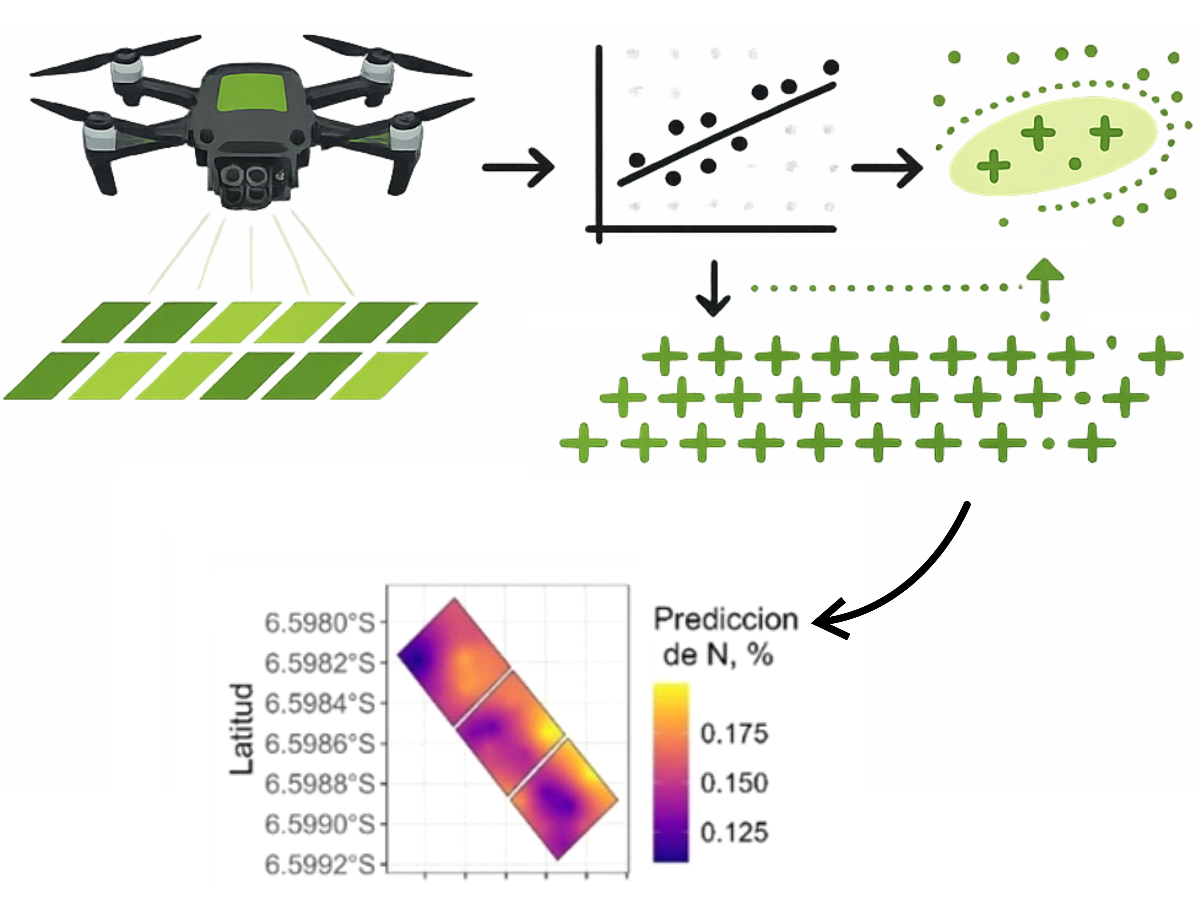
Spatial variability of soil properties is a key factor that influences productivity, nutrient management, and overall sustainability in tropical agricultural systems. This is especially true where differences in soil types make it difficult to apply site-specific management strategies. In this context, the study sets out to compare the performance of the same analytical workflow based on multispectral UAV imagery, multiple linear regression, and geostatistical interpolation, across two tropical farming systems that differ in their level of structural heterogeneity. One was a station-wide multicrop system, and the other was a rice system under varying planting densities, both located at the El Porvenir Agricultural Experimental Station in San Martín, Peru. The study included 60 soil samples from the multicrop component and 27 from the rice system. All samples were georeferenced and taken at 30 cm depth, then analyzed in the lab for pH, electrical conductivity, nitrogen, phosphorus, potassium, soil organic carbon, and texture. The exact same workflow was applied to both systems: Spearman correlation, stepwise multiple linear regression, and ordinary kriging. Results showed that the rice system gave better predictive accuracy for specific variables like nitrogen and phosphorus. On the other hand, the multicrop component proved more useful for mapping spatial patterns and defining management zones, thanks to its greater heterogeneity. In addition, indices based on NIR and red edge bands had stronger links with the main soil properties. Overall, the performance of the approach clearly depended on the structural heterogeneity of each system: more uniform environments favored point-based predictions, while more variable ones were better suited for operational zoning.
References
Caroppo, A., Diraco, G., & Leone, A. (2026). A Systematic Review of Available Multispectral UAV Image Datasets for Precision Agriculture Applications. Remote Sensing, 18(4), 659. https://doi.org/10.3390/rs18040659
Chen, Y., Shi, T., Li, Q., Yang, C., Wang, Z., Chen, Z., & Pan, X. (2024). Mapping Soil Properties in Tropical Rainforest Regions Using Integrated UAV-Based Hyperspectral Images and LiDAR Points. Forests, 15(12), 2222. https://doi.org/10.3390/f15122222
EPA. (2004). Method 9045D: Soil and Waste pH. United States Environmental Protection Agency.
Flores, R., Bahia, R. de C., Arévalo, Y., Torres, E. E., Guevara, J., Antezana, A., Carranza, A., Lao, C., & Solórzano-Acosta, R. (2025). Intermittent Rainfed Rice var. INIA 516 LM1: A Sustainable Alternative for the Huallaga River Basin. Water, 17(9), 1262. https://doi.org/10.3390/w17091262
Gade, S. A., Madolli, M. J., García‐Caparrós, P., Ullah, H., Cha-um, S., Datta, A., & Himanshu, S. K. (2025). Advancements in UAV remote sensing for agricultural yield estimation: A systematic comprehensive review of platforms, sensors, and data analytics. Remote Sensing Applications: Society and Environment, 37, 101418. https://doi.org/10.1016/j.rsase.2024.101418
Gee, G. W., & Or, D. (2002). Particle Size Analysis. In: Dane, J.H. and Topp, G.C., Eds., Methods of Soil Analysis, Part 4, Physical Methods, Soils Science Society of America, Book Series No. 5, Madison. Soils Science Society of America.
ISO 11265. (1994). Soil quality - Determination of the specific electrical conductivity. International Organization for Standardization.
Jhajharia, K., Sharma, N. V., & Mathur, P. (2025). A Machine Learning Model for Crop Yield Prediction Using Remote Sensing Data. International Research Journal of Multidisciplinary Scope. https://doi.org/10.47857/irjms.2025.v06i02.03182
Liang, Z., Fu, Z., Kiplagat, D., Wang, W., Yang, J., Li, Z., & , Qiang Cao, Yongchao Tian, Yan Zhu, Weixing Cao, X. L. (2025). Rice yield prediction base on UAV multispectral imagery using machine learning methods. Smart Agricultural Technology, 12, 101549. https://doi.org/10.1016/j.atech.2025.101549
Ma, Z. ., Xu, D. ., Qiu, Z. ., Fang, L. ., Wang, M. ., Wang, Z. ., Bao, R. ., Tang, Q. ., Song, X. ., Tan, C. ., & Li, Z. (2026). Integrating UAV, environmental, and management data to improve rice nitrogen nutrition index prediction using an ensemble learning algorithm. BMC Plant Biology. https://doi.org/10.1186/s12870-026-08602-x
Mena, F., Pathak, D., Najjar, H., Sanchez, C., Helber, P., Bischke, B., Habelitz, P., Miranda, M., Siddamsetty, J., Nuske, M., Charfuelan, M., Arenas, D., Vollmer, M., & Dengel, A. (2025). Adaptive fusion of multi-modal remote sensing data for optimal sub-field crop yield prediction. Remote Sensing of Environment, 318, 114547. https://doi.org/10.1016/j.rse.2024.114547
MIDAGRI. (2025). Observatorio de commodities arroz N.° 01 2025. https://repositorio.midagri.gob.pe/bitstream/20.500.13036/1984/1/Observatorio de commodities-arroz-n-01-2025.pdf
Mulvaney, R. L. (1996). Part 3. Chemical methods. Nitrogen- Inorganic forms. Methods of Soil Analysis.
Nelson, D. W., & Sommers, L. E. (2018). Total carbon, organic carbon, and organic matter. In Methods of Soil Analysis, Part 3: Chemical Methods. https://doi.org/10.2136/sssabookser5.3.c34
Novais, J. J. M., Melo, B. M. D., Neves Junior, A. F., Lima, R. H. C., de Souza, R. E., Melo, V. F., do Amaral, E. F., Tziolas, N., & Demattê, J. A. M. (2025). Online analysis of Amazon’s soils through reflectance spectroscopy and cloud computing can support policies and the sustainable development. Journal of Environmental Management, 375, 124155. https://doi.org/10.1016/j.jenvman.2025.124155
Olsen, S. R., Cole, C. V, Watandbe, F., & Dean, L. (1954). Estimation of Available Phosphorus in Soil by Extraction with sodium Bicarbonate. Circular no. 939. Washington, D. C.
Peticilă, A., Iliescu, P. G., Dinca, L., Popa, A. S., & Murariu, G. (2025). Vegetation Indices from UAV Imagery: Emerging Tools for Precision Agriculture and Forest Management. In AgriEngineering, 7(12), 431. https://doi.org/10.3390/agriengineering7120431
Quille, J., Ramos, L., Huanuqueño, J., Quispe, D., Cruz, L., Pino, E., Flores, L., Heros, E., & Ruiz, L. (2025). Rice Yield Prediction Using Spectral and Textural Indices Derived from UAV Imagery and Machine Learning Models in Lambayeque, Peru. Remote Sensing, 17(4), 632. https://doi.org/10.3390/rs17040632
Rhoades, J. D. (2018). Salinity: Electrical conductivity and total dissolved solids. In Methods of Soil Analysis, Part 3: Chemical Methods. https://doi.org/10.2136/sssabookser5.3.c14
Saha, S., Kucher, O. D., Utkina, A. O., & Rebouh, N. Y. (2025). Precision agriculture for improving crop yield predictions: a literature review. Frontiers in Agronomy, 7, 1566201 https://doi.org/10.3389/fagro.2025.1566201
SEMARNAT. (2002). Norma Oficial Mexicana NOM-021-RECNAT-2000, Que establece las especificaciones de fertilidad, salinidad y clasificación de suelos. Estudios, muestreo y análisis. Diario Oficial de La Federación.
Solórzano, R. ., Cruz, J. ., Chuchon, R. ., Romero, L. E. ., Lozano, A.., Gaona, N. ., & Vallejos, G. (2025). The conversion of forests to agricultural croplands significantly depletes soil organic carbon reserves, total nitrogen, and available potassium, reaching critical thresholds in the Peruvian Amazon. Frontiers in Soil Science, 5, 1662180. https://doi.org/10.3389/fsoil.2025.1662180
Sparks D. L. (1996). Methods of soil analysis. Part 3-Chemical Methods. In Soil Science Society of America Inc., American Society of Agronomy Inc.
Suleymanov, A., Komissarov, Mikhail Aivazyan, M., Suleymanov, R., & Bikbaev, I. (2025). Unmanned Aerial Vehicles Applicability to Mapping Soil Properties Under Homogeneous Steppe Vegetation. Land, 14, 5. https://doi.org/10.3390/land14050931
Tripathi, R., Gouda, A. K., Jena, S. S., Mohapatra, R. R., Lal, M. K., Dash, S. K., Sahoo, R. N., & Nayak, A. K. (2025). Rice yield prediction using UAV-mounted RGB sensors and machine learning algorithms. Proceedings of the Indian National Science Academy. https://doi.org/10.1007/s43538-025-00479-y
USDA. (2025). Grain and feed annual: Peru, report PE2025 0008. In Grain and feed annual: Peru, report PE2025 0008.
Vullaganti, N., Ram, B., & Sun, X. (2025). Precision agriculture technologies for soil site-specific nutrient management: A comprehensive review. Artificial Intelligence in Agriculture, 15(2), 147-161. https://doi.org/10.1016/j.aiia.2025.02.001
Zhang, L., Liang, X., Li, X., Zeng, K., Chen, Q., & Zhao, Z. (2025a). Machine Learning Models for Yield Estimation of Hybrid and Conventional Japonica Rice Cultivars Using UAV Imagery. Sustainability, 17(18), 8515. https://doi.org/10.3390/su17188515
Zhang, S., Wang, X., Lin, H., Dong, Y., & Qiang, Z. (2025b). A review of the application of UAV multispectral remote sensing technology in precision agriculture. Smart Agricultural Technology, 12, 101406 https://doi.org/10.1016/j.atech.2025.101406
Žydelis, R. ., Weihermüller, L. ., Gomes, L. C. ., Møller, A. B. ., Castaldi, F. ., et al. (2026). Comparison of soil property predictions in Lithuanian croplands using UAV, satellite, EMI data and machine learning. Computers and Electronics in Agriculture, 244(15), 111543. https://doi.org/10.1016/j.compag.2026.111543
Downloads
Published
How to Cite
Issue
Section
License
Copyright (c) 2026 Scientia Agropecuaria

This work is licensed under a Creative Commons Attribution-NonCommercial 4.0 International License.
The authors who publish in this journal accept the following conditions:
a. The authors retain the copyright and assign to the magazine the right of the first publication, with the work registered with the Creative Commons attribution license, which allows third parties to use the published information whenever they mention the authorship of the work and the First publication in this journal.
b. Authors may make other independent and additional contractual arrangements for non-exclusive distribution of the version of the article published in this journal (eg, include it in an institutional repository or publish it in a book) as long as it clearly indicates that the work Was first published in this journal.
c. Authors are encouraged to publish their work on the Internet (for example, on institutional or personal pages) before and during the review and publication process, as it can lead to productive exchanges and a greater and faster dissemination of work Published (see The Effect of Open Access).


