
Sustainable livestock farming: Estimating forage biomass with RPAS and 3D modeling
DOI:
https://doi.org/10.17268/sci.agropecu.2026.024Palabras clave:
grass height, grass volume, pasture mixture, structure from motion, droneResumen
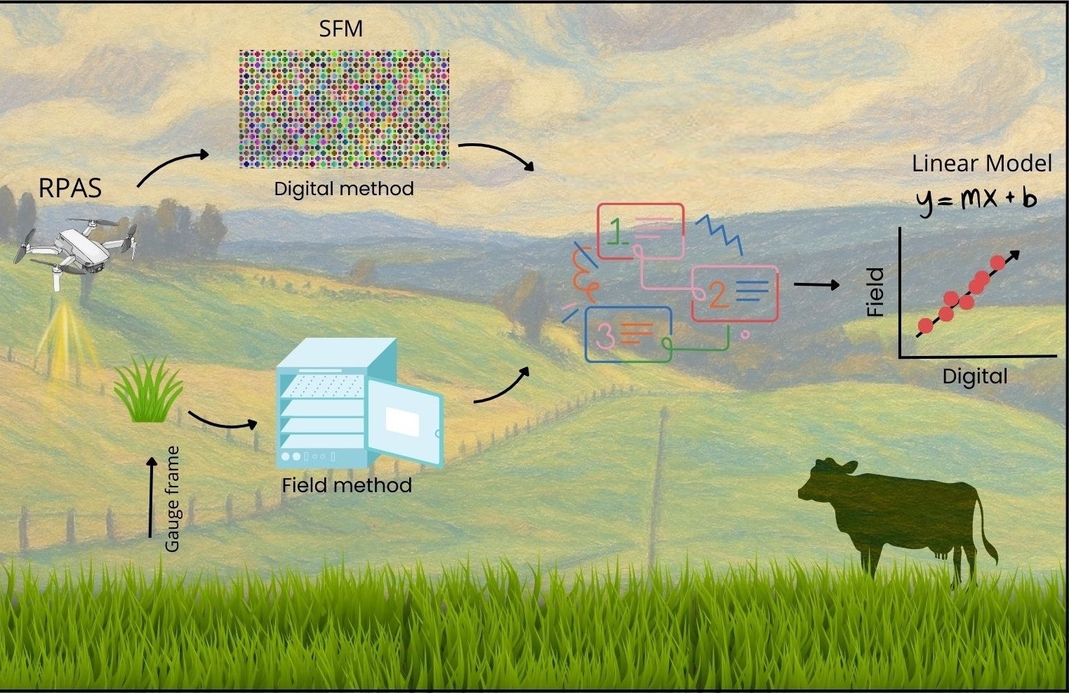
An alternative to support sustainable and technological livestock farming is using aerial images through Remotely Piloted Aircraft Systems (RPAS). This method has demonstrated effective outcomes in assessing agricultural variables including height, volume, and biomass across vegetation and crops like pastures. The study was carried out at Nero farm in southern Ecuador. The objectives of this research were: i) demonstrate the validity of the aerial imagery method with traditional field methods for characterizing grassland agronomic parameters (height, volume, and biomass) and ii) evaluate which of the variables studied (height and volume) is the best predictor of grass fresh mass and dry mass. The first methodology consists of collecting in filed (paddock) height and volume of grass using a frame of 1 m2, then biomass was measured in laboratory. For the second method, aerial images were obtained through RPAS and processed to generate digital surface model (DSM) and digital terrain model (DTM). Finally, linear models were performed with respective R2 and error. The height and volume of grass of both methods represent up to 98% of data variability (p < 0.0001), also, the measures of central tendency and dispersion were so similar. Regarding the models of fresh and dry mass with height and volume digital of grass representing over 40% (p < 0.05), the digital height being the best predictor for dry (R2: 48%) and fresh mass (R2: 42%). This research revalidates the effectiveness use of aerial images in important crops from Ecuador.
Citas
Batistoti, J., Marcato, J., ítavo, L., Matsubara, E., Gomes, E., Oliveira, B., Souza, M., Siqueira, H., Filho, G. S., Akiyama, T., Gonçalves, W., Liesenberg, V., Li, J., & Dias, A. (2019). Estimating pasture biomass and canopy height in Brazilian Savanna using UAV photogrammetry. Remote Sensing, 11(20), 1–12. https://doi.org/10.3390/rs11202447
Bazzo, C. O. G., Kamali, B., Hütt, C., Bareth, G., & Gaiser, T. (2023). A Review of Estimation Methods for Aboveground Biomass in Grasslands Using UAV. Remote Sensing, 15(3). https://doi.org/10.3390/rs15030639
Benalcazar-Carranza, B. P., Lopez-Caiza, V. C., Gutierrez-Leon, A., Alvarado-Ochoa, S., & Portilla-Narvaez, R. (2021). Effect of nitrogen fertilization on the growth of five perennial pastures in Ecuador. Pastos y Forrajes, 44(1), 1–9. https://www.redalyc.org/articulo.oa?id=269169781005
Blanco, S. R., Heras, D. B., & Argüello, F. (2020). Texture extraction techniques for the classification of vegetation species in hyperspectral imagery: Bag of words approach based on superpixels. Remote Sensing, 12(16), 1–24. https://doi.org/10.3390/RS12162633
Bonin, M. N., Ítavo, C. C. B. F., Ítavo, L. C. V., Gomes, M. N. B., Souza, A. I., Difante, G. S., Arco, T. F. F. S., Ferelli, K. L. S. M., Soares, S. M., Gurgel, A. L. C., & Surita, L. M. A. (2023). Extruded urea could replace true protein source in supplements for lambs finished in tropical pastures. Arquivo Brasileiro de Medicina Veterinaria e Zootecnia, 75(1), 89–97. https://doi.org/10.1590/1678-4162-12645
Botello-Aguillón, C., Gavi-Reyes, F., Tijerina-Chávez, L., Galvis-Spíndola, A., & Roblero-Hidalgo, R. (2019). Estimación de biomasa aérea de forrajes de invierno bajo riego a través de un dron. Agro Productividad, 12(4). https://doi.org/10.32854/agrop.v0i0.354
Castillo, E. C., Pellat, F. P., & Bolaños González, M. A. (2017). Estimación de biomasa y cobertura aérea usando radiometría e imágenes digitales a nivel de campo en pastizales y matorrales. Terra Latinoamericana, 35(3). https://doi.org/10.28940/terra.v35i3.133
Contreras, F., Cayuela, M. L., Sánchez-Monedero, M. A., & Pérez-Cutillas, P. (2025). Multi-source remote sensing for large-scale biomass estimation in Mediterranean olive orchards using GEDI LiDAR and machine learning. Biogeosciences, 22(23), 7625-7646. https://doi.org/10.5194/bg-22-7625-2025
De Rosa, D., Basso, B., Fasiolo, M., Friedl, J., Fulkerson, B., Grace, P. R., & Rowlings, D. W. (2021). Predicting pasture biomass using a statistical model and machine learning algorithm implemented with remotely sensed imagery. Computers and Electronics in Agriculture, 180(July 2020), 105880. https://doi.org/10.1016/j.compag.2020.105880
Debangshi, U. (2021). Drones - Applications in Agriculture. Chronicle of Bioresource Management, 5(September), 115–120. https://doi.org/https://doi.org/10.5281/zenodo.5554733
Espinosa-Valdez, A., Polo-Castaneda, M., & Gomez-Rojas, J. (2024). Mixed model for counting banana plant leaves using aerial drone images for plant health management. 2024 IEEE International Conference on Automation/26th Congress of the Chilean Association of Automatic Control, ICA-ACCA 2024, February. https://doi.org/10.1109/ICA-ACCA62622.2024.10766758
Fenetahun, Y., Xu, X. W., & Wang, Y. D. (2020). Forage composition, biomass and carrying capacity dynamics in yabello rangeland, southern ethiopia using different grazing sites. Applied Ecology and Environmental Research, 18(5), 7233–7253. https://doi.org/10.15666/aeer/1805_72337253
GAD, B. (2021). Actualización del Plan de Ordenamiento Territorial Parroquial Rural de Baños. https://parroquiabanos.gob.ec/download/planificacion/pdot/PDOT-BANOS-V103_16032021.pdf
Geipel, J., Link, J., & Claupein, W. (2014). Combined spectral and spatial modeling of corn yield based on aerial images and crop surface models acquired with an unmanned aircraft system. Remote Sensing, 6(11), 10335–10355. https://doi.org/10.3390/rs61110335
Gillan, J. K., McClaran, M. P., Swetnam, T. L., & Heilman, P. (2019). Estimating forage utilization with drone-based photogrammetric point clouds. Rangeland Ecology and Management, 72(4), 575–585. https://doi.org/10.1016/j.rama.2019.02.009
Guevara-Escobar, A., Cervantes-Jiménez, M., Lemus-Ramírez, V., Yabuta-Osorio, A. K., & García-Muñiz, J. G. (2023). Estimation of forage mass in a mixed pasture by machine learning, pasture management and satellite meteorological data. Revista Mexicana De Ciencias Pecuarias, 14(1), 61–77. https://doi.org/10.22319/rmcp.v14i1.6162
Gustavo, L., Durante, Y., Cortez, J. W., Souza, J. E. De, & De, A. V. (2025). Using aerial imagery for assessing pasture vegetation coverage. Revista Ciência Agronômica, 56(1), 1–11. https://doi.org/10.5935/1806-6690.20250053
Guth, P. L., Van Niekerk, A., Grohmann, C. H., Muller, J. P., Hawker, L., Florinsky, I. V., Gesch, D., Reuter, H. I., Herrera-Cruz, V., Riazanoff, S., López-Vázquez, C., Carabajal, C. C., Albinet, C., & Strobl, P. (2021). Digital elevation models: Terminology and definitions. Remote Sensing, 13(18). https://doi.org/10.3390/rs13183581
Han, X., Thomasson, J. A., Bagnall, G. C., Pugh, N. A., Horne, D. W., Rooney, W. L., Jung, J., Chang, A., Malambo, L., Popescu, S. C., Gates, I. T., & Cope, D. A. (2018). Measurement and Calibration of Plant-Height from Fixed-Wing UAV Images. Sensors, 18(12). https://doi.org/10.3390/s18124092
Hao, S., Huang, X., Duan, Z., Hou, J., Chen, W., & Cai, L. (2025). Research on the Method for Pairing Drone Images with BIM Models Based on Revit. Drones, 9(3). https://doi.org/10.3390/drones9030215
Hassnain, S. A., Othman, N., Li, Y., Alsharif, M., & Khan, M. (2023). Unmanned aerial vehicles (UAVs): practical aspects, applications, open challenges, security issues, and future trends. Intelligent Service Robotics, 16, 109–137. https://doi.org/10.1007/s11370-022-00452-4
Hayatu Ibrahim, K., & Abubakar Usman, L. (2021). Management Practices of Pasture, Range and Grazing Reserves for Livestock Production in the Tropics: A Review. American Journal of Entomology, 5(2), 18. https://doi.org/10.11648/j.aje.20210502.11
Hoelzer, K., & Eskin, S. (2017). Food Safety From Farm to Fork (Issue July). https://www.pew.org/-/media/assets/2017/07/food-safety-from-farm-to-fork-final.pdf
Hott, M. C., Andrad, R. G., D’Oliveira, P. S., Motta, M. B., Rocha, W. S. D. da, & Magalhães Junior, W. C. P. de. (2024). Remote Sensing Applied to Pasture Monitoring: A Review. Revista de Gestão Social e Ambiental, 18(7), e08355. https://doi.org/10.24857/rgsa.v18n7-161
Huang, L., Zhao, F., Hu, G., Ganjurjav, H., Wu, R., & Gao, Q. (2024). Evaluation of Machine Learning Models for Estimating Grassland Pasture Yield Using Landsat-8 Imagery. Agronomy, 14(12), 1–16. https://doi.org/10.3390/agronomy14122984
Iñamagua-Uyaguari, J. P., Green, D. R., Fitton, N., Sangoluisa, P., Torres, J., & Smith, P. (2022). Use of Unoccupied Aerial Systems to Characterize Woody Vegetation across Silvopastoral Systems in Ecuador. Remote Sensing, 14(14). https://doi.org/10.3390/rs14143386
INEC. (2024). Encuesta de superficie y producción agropecuaria continua. In Instituto Nacional de Estadísticas y Censos. https://www.ecuadorencifras.gob.ec/documentos/web-inec/Estadisticas_agropecuarias/espac/2024/Presentacion_de_resultados_ESPAC_2024.pdf
Jacq, K., Ployon, E., Rapuc, W., Blanchet, C., Pignol, C., Coquin, D., Fanget, B., Jacq, K., Ployon, E., Rapuc, W., Blanchet, C., & Pignol, C. (2021). photogrammetry applied to line-scan sediment core images To cite this version : HAL Id : hal-03257581 Structure-from-Motion , Multi-View Stereo photogrammetry applied to. Journal of Paleolimnology, 66(3), 1–30. https://doi.org/https://doi.org/10.1007/s10933-021-00204-x
Jang, E., & Kang, W. (2024). Estimating Riparian Vegetation Volume in the River by 3D Point Cloud from UAV Imagery and Alpha Shape. Applied Sciences (Switzerland), 14(1). https://doi.org/10.3390/app14010020
Lemenkova, P., & Debeir, O. (2022). Satellite Image Processing by Python and R Using Landsat 9 OLI/TIRS and SRTM DEM Data on Côte d’Ivoire, West Africa. Journal of Imaging, 8(12), 1–33. https://doi.org/10.3390/jimaging8120317
Lussem, U., Schellberg, J., & Bareth, G. (2020). Monitoring Forage Mass with Low-Cost UAV Data: Case Study at the Rengen Grassland Experiment. PFG - Journal of Photogrammetry, Remote Sensing and Geoinformation Science, 88(5), 407–422. https://doi.org/10.1007/s41064-020-00117-w
Magar, L. P., Sandifer, J., Khatri, D., Poudel, S., Kc, S., Gyawali, B., Gebremedhin, M., & Chiluwal, A. (2025). Plant height measurement using UAV-based aerial RGB and LiDAR images in soybean. Frontiers In Plant Science, 16, 1488760. https://doi.org/10.3389/fpls.2025.1488760
Mashraqi, A. M., Asiri, Y., Algarni, A. D., & Abu-Zinadah, H. (2022). Drone Imagery Forest Fire Detection and Classification Using Modified Deep Learning Model. Thermal Science, 26(Special Issue 1), S411–S423. https://doi.org/10.2298/TSCI22S1411M
Matsuura, Y., Heming, Z., Nakao, K., Qiong, C., Firmansyah, I., Kawai, S., Yamaguchi, Y., Maruyama, T., Hayashi, H., & Nobuhara, H. (2023). High-precision plant height measurement by drone with RTK-GNSS and single camera for real-time processing. Scientific Reports, 13(1), 1–15. https://doi.org/10.1038/s41598-023-32167-6
Mónaco, N., Santa, V., Rosa, M. J., & Autran, V. (2017). Evaluación de métodos indirectos para estimar biomasa en un pastizal natural del sur de Córdoba (Argentina Central). European Scientific Journal, ESJ, 13(36), 59. https://doi.org/10.19044/esj.2017.v13n36p59
Murphy, D. J., Murphy, M. D., O’brien, B., & O’donovan, M. (2021). A review of precision technologies for optimising pasture measurement on irish grassland. Agriculture (Switzerland), 11(7), 1–36. https://doi.org/10.3390/agriculture11070600
Ogungbuyi, M. G., Mohammed, C., Ara, I., Fischer, A. M., & Harrison, M. T. (2023). Advancing Skyborne Technologies and High-Resolution Satellites for Pasture Monitoring and Improved Management: A Review. Remote Sensing, 15(19). https://doi.org/10.3390/rs15194866
Pérez-Harguindeguy, N., Díaz, S., Garnier, E., Lavorel, S., Poorter, H., Jaureguiberry, P., Bret-Harte, M. S., Cornwell, W. K., Craine, J. M., Gurvich, D. E., Urcelay, C., Veneklaas, E. J., Reich, P. B., Poorter, L., Wright, I. J., Ray, P., Enrico, L., Pausas, J. G., De Vos, A. C., … Cornelissen, J. H. C. (2013). New handbook for standardised measurement of plant functional traits worldwide. Australian Journal of Botany, 61(3), 167–234. https://doi.org/10.1071/BT12225
Pino Peralta, S., & Ortega Álvarez, K. (2024). Análisis de los principales indicadores socioeconómicos del sector agropecuario ecuatoriano (2000-2022). Perspectivas Rurales Nueva Época, 22(43), 1–32. https://doi.org/10.15359/prne.22-43.12
Pun Magar, L., Sandifer, J., Khatri, D., Poudel, S., KC, S., Gyawali, B., Gebremedhin, M., & Chiluwal, A. (2025). Plant height measurement using UAV-based aerial RGB and LiDAR images in soybean. Frontiers in Plant Science, 16(January), 1–16. https://doi.org/10.3389/fpls.2025.1488760
Quille-Mamani, J., Porras-Jorge, R., Saravia-Navarro, D., Herrera, J., Chávez-Galarza, J., Arbizu, C. I., & Valqui-Valqui, L. (2022). Assessment of vegetation indices derived from UAV images for predicting biometric variables in bean during ripening stage. IDESIA, 40, 2022.
R Core Team. (2024). R: A language and environment for statistical computing. R Foundation for Statistical Computing. https://www.r-project.org
Rose, M. B., Mills, M., Franklin, J., & Larios, L. (2023). Mapping Fractional Vegetation Cover Using Unoccupied Aerial Vehicle Imagery to Guide Conservation of a Rare Riparian Shrub Ecosystem in Southern California. Remote Sensing, 15(21). https://doi.org/10.3390/rs15215113
Rueda-Ayala, V. P., Peña, J. M., Höglind, M., Bengochea-Guevara, J. M., & Andújar, D. (2019). Comparing UAV-based technologies and RGB-D reconstruction methods for plant height and biomass monitoring on grass ley. Sensors (Switzerland). https://doi.org/10.3390/s19030535
Santos, W. M. dos, Martins, L. D. C. de S., Bezerra, A. C., Souza, L. S. B. de, Jardim, A. M. da R. F., Silva, M. V. da, Souza, C. A. A. de, & Silva, T. G. F. da. (2024). Use of Unmanned Aerial Vehicles for Monitoring Pastures and Forages in Agricultural Sciences: A Systematic Review. Drones, 8(10). https://doi.org/10.3390/drones8100585
Segura, C., Horrocks, C., Lopez-Aizpun, M., Blackwell, M. S. A., Darch, T., Hood, J., Le Cocq, K., McAuliffe, G. A., Lee, M. R. F., & Cardenas, L. (2023). Response of soil health indicators to dung, urine and mineral fertilizer application in temperate pastures. Journal of Environmental Management, 330, 117096. https://doi.org/10.1016/j.jenvman.2022.117096
Sharma Banjade, S., Rai, N., & Subedi, B. (2024). Comparison of Supervised Classification Algorithms Using a Hyperspectral Image for Land Use/Land Cover Classification. Environmental Sciences Proceedings, 29(1), 59. https://doi.org/10.3390/ecrs2023-16702
Sinde-González, I., Gil-Docampo, M., Arza-García, M., Grefa-Sánchez, J., Yánez-Simba, D., Pérez-Guerrero, P., & Abril-Porras, V. (2021). Biomass estimation of pasture plots with multitemporal UAV-based photogrammetric surveys. International Journal of Applied Earth Observation and Geoinformation, 101(April). https://doi.org/10.1016/j.jag.2021.102355
Song, M., Zhang, Y., Hu, L., Liu, Y., Yang, J., Li, Z., Bai, B., & Li, G. (2025). High-throughput plant height measurement for the field peanuts from low-cost UAV photogrammetry. ISPRS Annals Of The Photogrammetry, Remote Sensing And Spatial Information Sciences, X-1/W2-2025, 133-138. https://doi.org/10.5194/isprs-annals-x-1-w2-2025-133-2025
Tang, Z., Xia, X., Huang, Y., Lu, Y., & Guo, Z. (2022). Estimation of National Forest Aboveground Biomass from Multi-Source Remotely Sensed Dataset with Machine Learning Algorithms in China. Remote Sensing, 14(21). https://doi.org/10.3390/rs14215487
Vafidis, J., Lucksted, I., Gall, M., Maxfield, P., Meakin, K., & Steer, M. (2021). Mapping scrub vegetation cover from photogrammetric point clouds: A useful tool in reserve management. Ecology and Evolution, 11(11), 6789–6797. https://doi.org/10.1002/ece3.7527
Vahidi, M., Shafian, S., Thomas, S., & Maguire, R. (2023). Pasture Biomass Estimation Using Ultra-High-Resolution RGB UAVs Images and Deep Learning. Remote Sensing, 15(24). https://doi.org/10.3390/rs15245714
Varela, S., Assefa, Y., Vara Prasad, P. V., Peralta, N. R., Griffin, T. W., Sharda, A., Ferguson, A., & Ciampitti, I. A. (2017). Spatio-temporal evaluation of plant height in corn via unmanned aerial systems. Journal of Applied Remote Sensing, 11(03), 1. https://doi.org/10.1117/1.jrs.11.036013
Wang, Y., Tan, L., Wang, G., Sun, X., & Xu, Y. (2022). Study on the Impact of Spatial Resolution on Fractional Vegetation Cover Extraction with Single-Scene and Time-Series Remote Sensing Data. Remote Sensing, 14(17), 1–16. https://doi.org/10.3390/rs14174165
Zayed, A. M. A., Saber, A., Hamama, M. A., Rabah, M., & Zaki, A. (2023). Evaluation of vertical accuracy of TanDEM-X Digital Elevation Model in Egypt. Egyptian Journal of Remote Sensing and Space Science, 26(4), 919–936. https://doi.org/10.1016/j.ejrs.2023.10.003
Zhang, Y., Wang, C., Huang, J., Wang, F., Huang, R., Lin, H., Chen, F., & Wu, K. (2020). Exploring the optical properties of leaf photosynthetic and photo-protective pigments in vivo based on the separation of spectral overlapping. Remote Sensing, 12(21), 1–16. https://doi.org/10.3390/rs12213615
Descargas
Publicado
Cómo citar
Número
Sección
Licencia
Derechos de autor 2026 Scientia Agropecuaria

Esta obra está bajo una licencia internacional Creative Commons Atribución-NoComercial 4.0.
Los autores que publican en esta revista aceptan los siguientes términos:
a. Los autores conservan los derechos de autor y conceden a la revista el derecho publicación, simultáneamente licenciada bajo una licencia de Creative Commons que permite a otros compartir el trabajo, pero citando la publicación inicial en esta revista.
b. Los autores pueden celebrar acuerdos contractuales adicionales separados para la distribución no exclusiva de la versión publicada de la obra de la revista (por ejemplo, publicarla en un repositorio institucional o publicarla en un libro), pero citando la publicación inicial en esta revista.
c. Se permite y anima a los autores a publicar su trabajo en línea (por ejemplo, en repositorios institucionales o en su sitio web) antes y durante el proceso de presentación, ya que puede conducir a intercambios productivos, así como una mayor citación del trabajo publicado (ver efecto del acceso abierto).


